Ewden Beck (14km)
- Posted
- Modified
- Author Sam
- Categories Peak Challenge, Stories
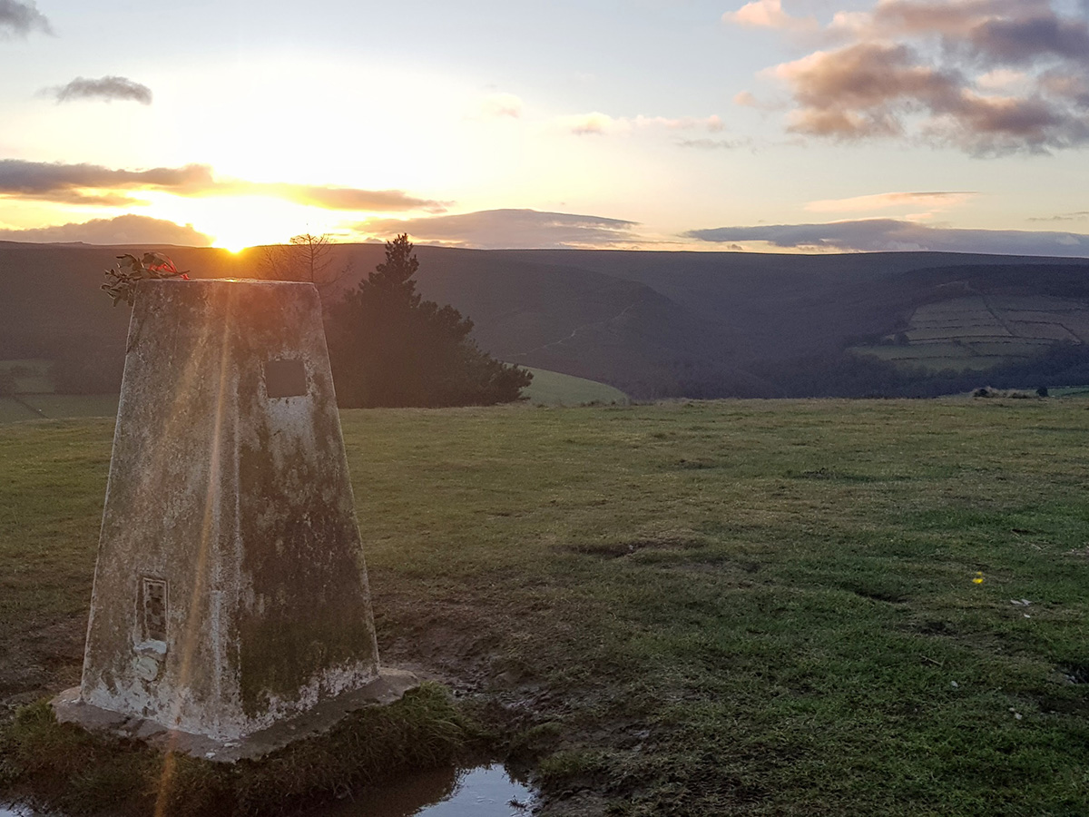
My latest Peak Challenge walk was inspired by a photo that I took on Christmas Eve 2020 from the trig point on Whitwell Moor, near Stocksbridge. The image quality isn’t the best, but the valley you can see in the background is Ewden Beck. It looked picturesque, and walk-round-able, so I decided to make it my next walk.

The forecast for the day was mixed, with patches of rain expected, and the chance of heavy fog. I made an early start as the heaviest rain was forecast for the afternoon, and drove the short distance from my house to the start point near the old Broomhead Hall, the ancestral home of the Rimington-Wilson family that I wrote about on my Midhope Moors walk. The hall itself was actually demolished in 1980, as detailed on the Stocksbridge & District History Society website, but the farm remains. There is parking for a couple of cars along the road here, but more is available at Whitwell Moor just up the hill.

The walk starts by following a track along the south bank of Ewden Beck. On the left hand side is scheduled monument number 1018590, Ewden Beck round barrow cemetery and cross-dyke. I walked up the hill to get a better view of the cross-dyke, but honestly it doesn’t do it for me. I’d welcome any recommendations for books or other resources to help me understand what I’m looking at, because all I see is a rather un-exciting drainage ditch… I was also looking out for the stone circle, and with hindsight I think I found it, but at the time I didn’t take a photo because it was so non-distinct.


After a while I reached the very attractive and well-maintained shooting lodge. I bet this is well-used in the summer. I headed round the back of the building and used the new-looking footbridge to cross the stream, which was in full flow due to the recent wet weather. I could see pale yellow foam swirling in clumps in the eddies, and I had always thought that this was due to fertiliser running off the land, but that wouldn’t make sense here. After doing some research I found this Environment Agency fact sheet which explains that the foam can be caused by natural surfactants created by decomposing vegetation. I’m pretty sure that explains the foam I saw, as the fact sheet specifically mentions “brown water that drains [from] bogs and wetlands”.


I followed the shooting butts access path until I reached Oaken Clough, where I left the path to head across Middle Moss Spring towards Stainery Clough. At first, the going was good, as the heather was short, soft and springy. But before long, the heather became deep and woody, and I kept stumbling as my foot disappeared into small peat gullies hidden below the heather. I was expecting the ground to be saturated and boggy, due to the recent rain, but the moor is relatively well-drained. Although I could hear lots of water draining away through cracks in the peat, the surface was fairly dry. Good for walkers, but bad for the ecosystem. At one point I was surprised by a hare jumping out of the heather in front of me. I couldn’t tell if it was a brown hare or a mountain hare. It definitely had a bright white tail.
I arrived at Stainery Clough and realized that it was going to be very difficult to cross this stream. First, the sides were extremely steep, rocky and overgrown, with no paths or even sheep-tracks leading to the bottom. Second, the stream was in full flow and I couldn’t see any good places to cross. I followed the valley upstream, extremely slowly due to the deep vegetation. The first time I tried to make my way down to the bottom, I slipped and fell down a few metres before getting stuck in the heather, so I pulled myself back up and headed away from the edge for a bit while I made some progress upstream. I finally found a place to cross, but had to lower myself down by grabbing onto handfuls of heather and hoping that each step would hold for long enough for me to get down! Hopefully the photo shows how steep it was here.

There is an aircraft wreck a short distance away and I’d hoped to visit it, but the going was so tough through the deep woody heather that I decided to give it a miss. I continued across Upper Commons and as reached Fox Stones the heather turned to bracken, lying in brown soggy clumps on the ground. The damp, dead stems kept catching my ankles, giving only a small amount of resistance before tearing away, and the feeling reminded me of swimming through kelp in the sea. I stopped at Fox Stones for an early lunch (Firepot’s Posh Porks and Beans), and among the stones I saw the burrow of an animal. Maybe a shelter used by the brown hares I had seen earlier?


After lunch, I continued across White Carr Ridge, following the path of least resistance through the shortest heather towards the grouse butts. From there I followed the track up to the last butts, then headed across the moorland again, trying to find the wall running along Earnshaw. I found the wall easily enough, and followed it all the way along to Barnside Moor.


The view up here was fantastic. To the south east you can see Broomhead and Ewden reservoirs, and to the north west you can see Langsett Reservoir. I love these spots where you can join the dots between places you know.
Following the track leads you to the old targets at Ewden Heights. These are part of the larger set of old military installations in the Langsett and Midhope area. I won’t write much about them here, because I plan on covering the topic in more detail when I visit the nearby Range Moor on a future walk.


I continued west back towards Mortimer Road. I hadn’t planned the next section of my walk in much detail as I was hoping that a path would exist through the fields along the road, even if the map didn’t show a right of way. Unfortunately I couldn’t see one, and I really didn’t want to walk along the road here (steep, windy, narrow road, narrow verges), so I followed the public footpath towards Salt Springs Farm. From there I took a mixture of marked and unmarked paths down the extremely steep and muddy hillside, past Nether House Farm. I really don’t recommend following in my footsteps here, as it wasn’t a pleasant walk, and I was glad to rejoin the road above Ewden Bridge and stay on the road while I walked back to my car.


To me, the concept of this walk appealed to me more than the execution! I enjoyed walking all the way around Ewden Beck, but it was tough going at various points and I know that I could plan a better walk now with my improved knowledge of the area. But that’s half the point of my Peak Challenge anyway, and it did bag me another 10 grid squares, so I’ll chalk this one up as a win.
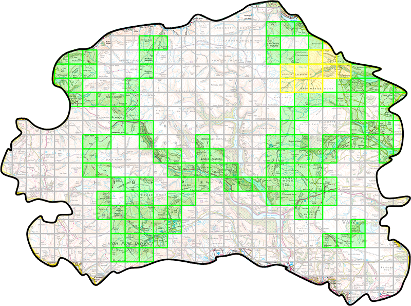
Yellow grid squares were completed on this route. Green grid squares were already completed.