Mapping Software Comparison: Viewing Routes
- Posted
- Modified
- Author Sam
- Categories Mapping Software Comparison
The last section of this article covered viewing maps, and this section covers viewing routes on those maps.
Before getting into the detail, it’s worth covering one fundamental difference first. Anquet, Mapyx Quo, Memory-Map and RouteBuddy all allow you to view multiple routes, tracks and waypoints at the same time, whereas the web-based OS Maps and ViewRanger only allow you to view a single route at once.


To me, being able to view multiple routes at the same time is essential, as I’m often overseeing several activities and need to be able to see where multiple groups will be walking. I also like to leave my own historic routes visible on my personal map overlay, so I can see where I’ve been.
Importing routes
GPX is the standard format for importing and exporting geographical information, and thankfully all the software covered in this article will import GPX with no problems. Mapyx Quo, Memory-Map and RouteBuddy support other formats as well, but GPX has become so universal that most users will never need to import anything else, so I won’t cover the other formats here.
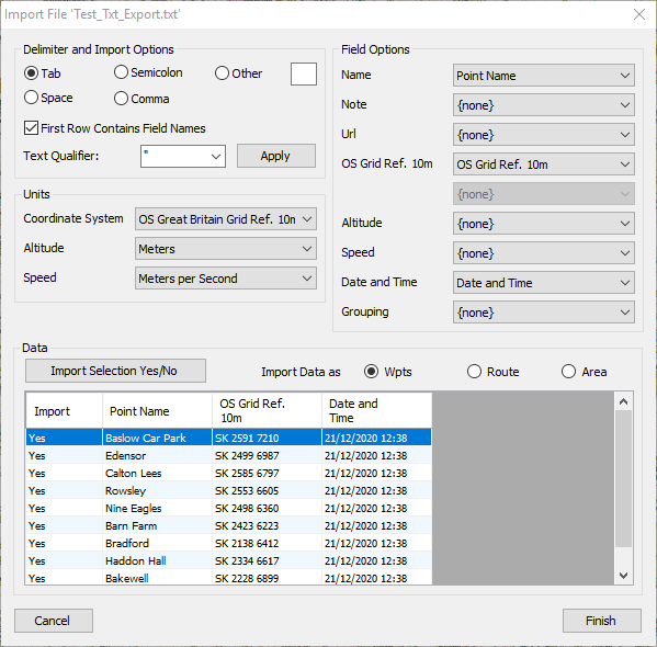
A nice feature that geeks like me will appreciate is the text import feature in Mapyx Quo. This powerful tool lets you import any text-based list of coordinates as a route, track or feature, and you can specify which fields in the document map to different fields in the software. This type of “power user” feature is probably irrelevant for most users, but I’ve used it on several occasions to import lists of waypoints, or import boundaries for a training area, that were originally given to me in text form on a document.
It’s also worth mentioning that OS Maps and ViewRanger have “social” features that let you browse through routes and share routes with others. All the routes on OS Maps are free but some of the routes on ViewRanger cost “credits” which you have to pay for. I cover the OS Maps social features in my detailed OS Maps review.
Route formatting
Typical formatting options include line colour, width and opacity (transparency), but some systems take this much further. Personally I prefer a wide, transparent line so I can see the detail underneath the line, but other people struggle to see this, and prefer a bold line that is offset from their intended route so it doesn’t obscure the detail.
For these screenshots I’ve aimed to show a the route/track using a thick, dashed, transparent, magenta line, with a direction-of-travel arrow if possible. Sorry if that’s not to your taste, but it does allow me to compare what’s available in each system! I’ve shown the options available for line formatting, and waypoint formatting, in the screenshots.
Starting with the most basic, ViewRanger offers no options except to change the colour of the route, and it only affects the app and not the web view. Actually, when I took the screenshot for this article, I couldn’t even get it to work in the app, as you can see below…


Slightly better is RouteBuddy which lets you change the colour, width and dashes of the line, but the setting affects every route at the same time, so it’s not possible to colour-code routes so you can tell them apart. RouteBuddy does have a nice way of showing the direction of travel, with small arrows, and the line is always slightly transparent. You can give waypoints custom icons, and waypoint labels are always visible.


Higher up the list is OS Maps which lets you select a colour, width and transparency from a predefined list. I like the styles available as they seem to have been carefully chosen, so although they are relatively limited, they cover all the options that most users would need. No support for waypoints although you can name points along your route if required.


Anquet has a more advanced offering based around the Line, Waypoint and Icon Style Managers. These let you define your own list of preset styles and apply them to routes and waypoints. You can set any line colour you like (RGB) and enter line width in pixels and set the opacity from 0-100%. You can also choose to show the direction of travel. Waypoints have a similar level of control and you can give them custom icons, and control whether labels are visible and what font and size they should be.


Unfortunately, the way that Anquet draws lines on the screen appears to be different to the other software, and they often look jagged and messy. Here’s a zoomed in example to show you what I mean:

Memory-Map has a good range of formatting, letting you select any colour you like (RGB), as well as the width, opacity and dashes from predefined lists. You can show direction of travel, and change the colour or add custom icons to waypoints along the route. I like how, with single-colour icons, you can pick your own colour. So, for example, you could use the same tent icon for all your campsites, but colour-code them red, amber and green for how much you like them.


Finally, the king of formatting has to be Mapyx Quo, with a staggering array of options for customising not only your routes and tracks, but also the waypoints, labels for these waypoints, and fill options areas. There’s not much that you can’t do, and if you’re interested in the full details, read my detailed Mapyx review for more.

Here’s a comparison table to fill in any gaps in my coverage:
| Viewing Routes | Anquet OMN | Mapyx Quo | Memory-Map | OS Maps | RouteBuddy | ViewRanger |
|---|---|---|---|---|---|---|
| Line formatting | ||||||
| Colour | Yes (RGB) | Yes (RGB) | Yes (RGB) | Yes (from 6) | Yes (RGB, global) | Yes (app only) |
| Width | Yes (px) | Yes (px) | Yes (from 4) | Yes (from 4) | Yes (from 5) | No |
| Opacity (transparency) | Yes (0-100) | Yes (0-255) | Yes (from 5) | Yes (from 6) | No | No |
| Dashes | No | Yes (from 4) | Yes (from 5) | No | Yes (from 5) | No |
| Show direction of travel | Yes | Yes | Yes | No | Yes | No |
| Waypoint formatting | ||||||
| Show/hide | No | Yes | Yes | No | No | No |
| Colour | No | Yes | Yes | No | No | No |
| Width | No | Yes | No | No | No | No |
| Opacity (transparency) | No | Yes | No | No | No | No |
| Custom icons | No | Yes | Yes | No | Yes | Yes |
| Label formatting | ||||||
| Show/hide | Yes | Yes | Yes | No | No | No |
| Font | Yes | Yes | Yes | No | No | No |
| Font colour | Yes | Yes | Yes | No | No | No |
| Background colour | Yes | Yes | Yes | No | No | No |
| Background opacity (transparency) | Yes | Yes | Yes (on/off) | No | No | No |
| Border colour | No | Yes | No | No | No | No |
| Position X and Y relative to point | No | Yes | No | No | No | No |
Route statistics
All the mapping software covered will show you a variety of route statistics, usually including flat distance, distance including elevation, ascent and descent. They will also all provide an elevation profile where you can hover over the elevation profile to pinpoint the relevant section of the route.


3D view
I really like 3D view as it helps to bring contour lines to life, especially for students who aren’t yet confident with interpreting contour lines accurately.
Anquet and RouteBuddy do not offer 3D view. Mapyx Quo offers a 3D view where you can pan, rotate and zoom the map manually. Memory-Map and OS Maps both offer animated fly-throughs of routes.
The look and feel of each system is very different, as Memory-Map will only allow you to use your map tiles (eg. OS Explorer or Landranger) for this, and OS Maps will only allow you to use aerial/satellite imagery. The 3D view in Memory-Map has contour lines as these are included on the base map. OS Maps 3D view has an option to enable or disable contour lines on top of the aerial/satellite imagery.


Remarks
The winner here for me is Mapyx for the powerful text import feature and unbeatable formatting options, although it definitely loses some marks for its 3D view, which is not as polished as its competitors.
Notable mentions
- OS Maps for its best-in-class 3D flythrough feature that uses aerial imagery to bring the landscape to life.
Areas for improvement
- The jaggedy lines produced by Anquet are distracting and are particularly bad with wide, transparent lines, which I use a lot.
Do you agree with my ranking? What features are most important to you? Leave your thoughts in a comment below.